
Introduction: The Hidden Ecological Reality of Santa Cruz Real Estate
For landowners, developers, and real estate professionals in Santa Cruz County, the journey toward building a dream home, expanding a residential lot, or executing a minor land division involves navigating unique geographic constraints. While topography, septic capacity, and coastal zoning are standard hurdles, a distinct ecological layer heavily impacts property development across regions like Scotts Valley, Felton, Ben Lomond, and the Santa Cruz Mountains: The Santa Cruz Sandhills.
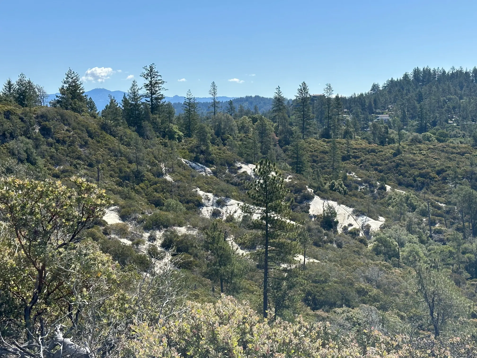
Formed over ten million years ago when an ancient sea floor rose to form portions of the Santa Cruz Mountain range, the Sandhills are a globally rare, highly localized ecosystem characterized by coarse Zayante sandy soils. Covering less than 4,000 remaining acres in the central part of the county, this ancient maritime environment is home to an array of endemic plant and animal species found nowhere else on Earth. Because of their severe geographic limitations and historical habitat fragmentation caused by quarrying and historical urban sprawl, these species are strictly protected by both federal and local laws.
The Sandhills Geological Chain:
- Ancient Sea Floor Maritime Sands →
- Extremely Porous Zayante Sandy Soils →
- Santa Cruz Sandhills Ecosystem (<4,000 Total Acres)
For a property owner, discovering that a parcel sits on Zayante soils can stall a project. Unresolved environmental impacts can trigger violations under the Federal Endangered Species Act (ESA) and the Santa Cruz County Sensitive Habitat Ordinance. Historically, navigating these regulations required complex biological assessments, custom habitat conservation plans, and exhaustive multi-year negotiations with the United States Fish and Wildlife Service (USFWS) and county planners. In many cases, projects were deemed economically or procedurally non-viable due to a lack of available off-site mitigation.
The establishment of the Zayante Sandhills Conservation Bank altered this landscape. By operating an approved, multi-agency-vetted framework, the bank provides eligible property owners with a straightforward, legally compliant path forward: the purchase of conservation credits. This guide provides a comprehensive roadmap for navigating Sandhills mitigation. It covers the biology of the habitat, the governing legal frameworks, the specific eligibility criteria of the Interim Programmatic Habitat Conservation Plan (IPHCP), and a step-by-step walkthrough of how to utilize the conservation bank to secure building permits.
1. Understanding the Sandhills Ecosystem and Protected Species
To successfully navigate the regulatory process, it is essential to understand why the Sandhills are heavily protected. The area consists of distinct vegetative communities—including sand parkland, ponderosa pine forest, and Sandhills chaparral—supporting highly specialized flora and fauna.
Endemic Fauna (The Wildlife)
- The Mount Hermon June Beetle (Polyphylla barbata): Listed as federally endangered in 1997, this highly specialized insect spends the vast majority of its life cycle underground as a larva, feeding silently on the root systems of Sandhills plants for roughly two to three years. Between May and September, adult males emerge from the sandy substrate at twilight to fly in search of mates. Because their surface activity is restricted to a narrow seasonal window, any unmitigated ground disturbance during these months can disrupt entire reproductive cohorts.
- The Zayante Band-Winged Grasshopper (Trimerotropis infantilis): Also listed as federally endangered in 1997, this small, heavily camouflaged grasshopper relies on open, sunny sand parkland environments. It uses bare sand patches to bask and regulate its body temperature. Urban encroachment, soil compaction, and the spread of invasive non-native ground covers directly eliminate the open sandy spaces required for its survival.
Endemic Flora (The Vegetation)
The unique soil chemistry and drainage characteristics of Zayante sands support specialized native plants, including:
- Ben Lomond Spineflower (Chorizanthe pungens var. hartwegiana): A low-growing annual herb covered in tiny, spine-tipped brackets that blooms in late spring.
- Santa Cruz Wallflower (Erysimum teretifolium): A striking, yellow-flowered biennial or short-lived perennial that thrives in open sandy clearings.
- Bonny Doon Silverleaf Manzanita (Arctostaphylos silvicola): A distinct, silver-hued evergreen shrub that forms structural components of the local chaparral.
When a project planner mentions "Sandhills Habitat," they are referring to the presence of these species or the specific soil profiles capable of supporting them. Any project that clears, grades, compacts, or covers this soil with impervious surfaces results in "take"—the legal term for harming, killing, or harassing a protected species or destroying its critical habitat.
2. The Legal Framework: Federal ESA vs. County Ordinances
Developing land within the Sandhills involves meeting overlapping requirements from local, state, and federal regulatory agencies.
The Federal Endangered Species Act (Section 10)
Under Section 9 of the Federal Endangered Species Act, it is unlawful for private citizens to cause the "take" of any federally listed endangered fish or wildlife species. To legally perform work that might incidentally cause take during otherwise lawful activities (such as building a home), a private landowner must obtain an Incidental Take Permit (ITP) from the USFWS under Section 10 of the Act.
Historically, obtaining an individual ITP required a landowner to independently draft a comprehensive Habitat Conservation Plan (HCP), fund extensive biological assessments, submit the plan for lengthy public review, and secure long-term preservation land. For an individual property owner building a single-family home or adding an accessory dwelling unit (ADU), this process often proved cost-prohibitive and time-consuming.
The Santa Cruz County Sensitive Habitat Ordinance (Chapter 16.32)
Concurrently, Santa Cruz County enforces its own local environmental protections via the Sensitive Habitat Ordinance. The county prohibits any development activity within a designated sensitive habitat unless it can be demonstrated that the project avoids or minimizes impacts to the maximum extent feasible, and that any unavoidable impacts are fully mitigated.
Because local authorities cannot issue a building permit that violates federal law, the county requires proof of federal compliance before granting structural or grading clearances. This creates a dual-layered regulatory system where the developer must clear both federal and local hurdles before breaking ground.
3. The IPHCP: A Streamlined Pathway for Small Parcels
To resolve this regulatory bottleneck for small-scale residential developments, a multi-agency effort culminated in the creation of the Interim Programmatic Habitat Conservation Plan (IPHCP) for the Sandhills. Collaborative agreements between the USFWS, the County of Santa Cruz, and the City of Scotts Valley established a programmatic framework. Instead of requiring every homeowner to write an individual conservation plan, the IPHCP serves as an umbrella mechanism. If a project meets strict eligibility requirements, it can utilize the pre-approved programmatic framework, substantially reducing permit processing times.
Key Geographic Focus Areas (Project Units)
The IPHCP specifically targets ten designated geographic "Project Units" situated across developed residential neighborhoods. These units are characterized by fragmented parcels that still contain Zayante soils and endangered species records. Significant designated units include:
- The Rollingwoods Unit: Encompassing roughly 184 acres near Graham Hill Road and Pasatiempo Drive, containing high-density small residential lots.
- The Whispering Pines Unit: Covering 373 acres bordered by Mount Hermon Road and Graham Hill Road, cutting directly through parts of Scotts Valley.
- The Scotts Valley West and East Units: Covering densely developed zones containing single-family parcels, townhomes, and light commercial spaces.
- The Zayante Road North and South Units: Comprising acreage adjacent to West Zayante Road, directly impacting rural residential properties.
Explicit Eligibility Criteria
To use the streamlined IPHCP pathway, a project must meet four criteria:
- Residential Intent: The proposed project must be residential in nature (e.g., constructing a single-family home, building a secondary unit/ADU, adding a deck, room addition, or detached garage). Commercial developments do not qualify for this programmatic route.
- Parcel Size Limitation: The subject parcel must be 1.5 acres or less in size. (Larger parcels occasionally receive individual exemptions from the Board of Supervisors based on project layout, but 1.5 acres remains the standard threshold).
- Maximum Ground Disturbance: The proposed construction activity must cause no more than 15,000 square feet of total ground disturbance per existing parcel. This calculation includes all areas impacted by grading, retaining walls, heavy equipment access pathways, and utility trenching.
- Avoidance & Minimization: The applicant must demonstrate that the building footprint minimizes impacts to native Sandhills habitat by using previously cleared or degraded areas of the lot wherever feasible.
CRITICAL COMPLIANCE NOTE ON THRESHOLDS:
If a project falls outside these boundaries (such as a commercial development, a subdivision resulting in larger lots, or a custom residential footprint exceeding 15,000 square feet of total ground disturbance), it cannot use the simplified programmatic track. For these larger footprints, the property owner will be required to draft and submit an independent, individual Habitat Conservation Plan (HCP) directly through the USFWS Ventura Field Office to secure an individual Incidental Take Permit.
4. The Role of the Zayante Sandhills Conservation Bank
When a project qualifies for the IPHCP or receives county approval for environmental mitigation, it must secure approved off-site habitat credits to offset its local impacts. This is the precise function of the Zayante Sandhills Conservation Bank.
Approved in April 2006 under the guidance of the USFWS and local authorities, the bank operates a dedicated 23-acre preserve known as the Ben Lomond Sandhills Preserve, located between Ben Lomond and Felton. Biologists have identified this contiguous habitat as critical for the survival of the Mount Hermon June beetle, Ben Lomond spineflower, and Santa Cruz wallflower.
Biological Benefits of Mitigation Banking
From an ecological standpoint, fragmented, piecemeal mitigation—such as trying to preserve a 500-square-foot patch of sand in a suburban backyard—is largely ineffective. Domestic pets, invasive landscaping (such as French broom or iceplant), and hardscaping isolate these small patches, making long-term species survival impossible.
The conservation bank addresses this issue by consolidating mitigation funds to manage a large, contiguous block of high-quality habitat. Protected in perpetuity by a formal conservation easement held and monitored by the Center for Natural Lands Management (CNLM), the bank utilizes funds from credit sales to pay for ongoing biological tracking, invasive plant eradication, and habitat restoration. This approach provides a documented biological benefit to the species while offering an efficient regulatory solution for property owners.
5. Step-by-Step Guide to Securing Your Sandhills Permit
If you own a property within the Sandhills habitat zone and intend to build or remodel, follow this step-by-step process to secure approval.
Step 1: Verification of Parcel Zoning and Sandhills Status
Before drafting architectural designs, determine if your property sits within a designated Sandhills habitat zone.
- Action: Access the Santa Cruz County Public GIS Web Mapping application. Enter your Assessor’s Parcel Number (APN) or street address.
- Evaluation: Check the environmental layers for "Sandhills" or "IPHCP Eligibility." If your parcel is flagged, your project must comply with local sensitive habitat regulations.
Step 2: Footprint Design, Minimization, and Disturbance Calculations
Work with your architect or designer to create a site plan that actively avoids high-quality native vegetation.
- Action: Map out all areas of proposed ground disturbance, including structural foundations, driveways, septic repairs, structural additions, and temporary construction staging areas.
- Rule of Thumb: Keep the total footprint under 15,000 square feet to avoid the complex individual HCP requirement. Orient the structure toward the most degraded portions of the property (e.g., areas dominated by non-native weeds or existing pavement) to satisfy the county's minimization requirements.
Step 3: Formal Application with the Planning Department
Submit your preliminary site plans to the Santa Cruz County Department of Community Development and Infrastructure (or the City of Scotts Valley, if applicable).
- Action: File a sensitive habitat review application alongside your standard building or grading permit request.
- Review: Environmental planning staff will review the plans and may conduct a site visit to verify that the proposed disturbance area is accurate and minimized.
Step 4: Environmental Review and Staff Reporting
Once planning staff determine that the project minimizes impacts and qualifies for the programmatic framework, they compile an environmental staff report.
- Action: Staff place the project's mitigation request onto the agenda of a regularly scheduled Santa Cruz County Board of Supervisors meeting as a "consent item."
- Outcome: Board approval formally authorizes the property owner to utilize the Zayante Sandhills Conservation Bank for off-site mitigation.
Step 5: Verification of Credit Availability and Reservation
With local authorization secured, contact the bank sponsors to secure your mitigation credits.
- Action: Reach out directly to the bank operators (Paul Burrowes or Owen Lawlor) to verify current credit availability and secure a formal pricing quote based on your exact square footage of ground disturbance.
- Important Caveat: Available credits fluctuated over time based on transaction ledger adjustments with the USFWS and the San Francisco District of the USACE. Securing a formal reservation ensures your project is backed by available inventory.
Step 6: Credit Purchase and Document Execution
Finalize the commercial transaction with the conservation bank.
- Action: Purchase the required credit allocation matching your square footage of disturbance. The bank will issue an official Certificate of Credit Purchase and update the regulatory ledger.
- Submittal: Provide copies of this certificate to the county planning department and the USFWS Ventura Field Office to prove your mitigation obligations are fully satisfied.
Step 7: Adhering to Seasonal Construction Restrictions
Securing the permit does not exempt the project from operational guidelines designed to protect local species during active construction.
- Seasonal Window: The IPHCP dictates that construction-related ground disturbance should minimize operations between May 15 and August 15. This period marks the peak flight season for the endangered Mount Hermon June Beetle and the primary growing season for the Ben Lomond Spineflower.
- Night Lighting: Minimize exterior night lighting during these summer months to avoid attracting and disrupting the nocturnal flight patterns of the June Beetle.
6. Special Configurations: Wells, Septic Repairs, and Complex Cases
Sandhills mitigation rules apply to more than just new home construction. Routine infrastructural maintenance and complex land management decisions also trigger these requirements.
Well Permits and Septic Repairs
When an existing home experiences a septic failure or requires a new water well within a Sandhills zone, the owner must complete a Sandhills Well/Septic Addendum through the Environmental Health Department. Homeowners typically choose between two mitigation options:
- Option 1: On-Site Restoration: Identify an area on the plot map equal to or greater than the total area disturbed by the well or septic work, and commit to restoring it by removing non-native invasive plants and replanting native Sandhills flora.
- Option 2: Mitigation Credit Purchase: Calculate the square footage of the repair disturbance and purchase equivalent credits from the Zayante Sandhills Conservation Bank, resolving the environmental tracking requirement within 120 days of permit issuance.
Minor Land Divisions and Development Consulting
For larger landowners looking to execute a minor land division (subdividing a parcel into four or fewer lots), the process requires careful master planning. Because subdivisions often expand the total long-term disturbance area across multiple prospective home sites, driveways, and utility corridors, developers must evaluate whether the cumulative project fits within programmatic thresholds or requires an individual, comprehensive Habitat Conservation Plan (HCP). Partnering with a consultant experienced in both local real estate and Sandhills mitigation frameworks can help ensure project viability.
7. Essential Contact Directory and Resources
To move your project forward, utilize the following direct contacts and official resources:
Regulatory Agencies
- Santa Cruz County Department of Community Development and Infrastructure (Environmental Planning)
701 Ocean Street, 4th Floor, Santa Cruz, CA 95060
Web: cdi.santacruzcountyca.gov - Santa Cruz County Environmental Health Division
Santa Cruz County Health Services Agency
Web: www.scceh.org - Brian Froelich
Senior Planner
City of Scotts Valley
Community Development Department
(831) 440-5634
Scotts Valley, CA | Official Website - U.S. Fish and Wildlife Service (Ventura Field Office)
Debora (Deb) Kirkland
Fish & Wildlife Biologist
Habitat Conservation Plan Coordinator
2493 Portola Road Suite B
Ventura, California 93003
debora_kirkland@fws.gov
Ventura Fish and Wildlife Office website
Phone: (805) 644-1766
Consultants
- Jodi M. McGraw, Ph.D.
Ecologist and Principal
Jodi McGraw Consulting (JMc)
PO Box 221 • Freedom, CA 95019
(831) 768-6988
jodi@jodimcgrawconsulting.com
www.jodimcgrawconsulting.com
Zayante Sandhills Conservation Bank
For credit availability, pricing inquiries, and Conservation Bank Agreements:
- Paul Burrowes
Phone: (408) 497-3989
Email: paul@zayantesandhills.com
Web: zayantesandhills.com - Owen Lawlor
Phone: (831) 212-8594
Additional Sandhills Information
- Sandhills Alliance for Natural Diversity (S.A.N.D.) The Santa Cruz Sandhills are a unique community of plants and animals found only on outcrops of Zayante sand soil in the central portion of Santa Cruz County, in central coastal California.
- Sempervirens Fund Nearly as ancient as redwoods—with fossil records dating back nearly to the dinosaurs—a 15-million year old sea floor emerges amongst the giants.
- Land Trust of Santa Cruz County Perched high above the bluffs, prairies, and forests of the central California coast lie a small collection of incredibly rare habitats known as the Santa Cruz Sandhills.
- Santa Cruz Museum of Natural History The Santa Cruz Sandhills are a rare habitat in the Santa Cruz mountains that support a very specific niche of plants and animals.
- Sandhills Monitoring - California State Parks Sandhills Monitoring At Wilder Ranch State Park
Conclusion: Balancing Local Development with Ecological Preservation
Navigating building regulations within sensitive habitats can feel daunting, but the presence of Zayante soils does not mean your residential project is unfeasible. By understanding the IPHCP's eligibility boundaries, keeping your project's physical footprint under the 15,000 square foot threshold to avoid an individual Habitat Conservation Plan for larger disturbance area, and leveraging the pre-approved framework of the Zayante Sandhills Conservation Bank, you can secure your permits efficiently and legally. This organized process satisfies complex federal and local environmental laws while actively contributing to the permanent preservation of Santa Cruz County's ancient maritime ecosystem.
Posted by Paul Burrowes onEnjoy this blog post? Click here to subscribe for updates
Leave A Comment